

The Daniel Boone National Forest is one of those fantastic places to spend days without running out of things to do.
Established in 1937, this national forest in Kentucky encompasses 708,000 acres of federally owned territory within a proclamation boundary of 2,100,000 acres.
Formerly known as the Cumberland National Forest, the forest’s name was changed in 1966 to honor Daniel Boone.
He was an explorer, pioneer of early American history, and founding father of Kentucky.
The Daniel Boone National Forest stretches across 21 counties in Kentucky, with four ranger districts, namely Cumberland, London, Redbird, and Stearns.
The forest’s terrain is mainly rocky, with numerous visible water features home to various flora and fauna, including reservoirs and major rivers.
All of these bodies of water flow into the Ohio River.
The park also has smaller streams that only flow after heavy rain.
Daniel Boone National Forest is a famous recreational and tourist attraction that serves a million or more visitors each year, with plenty of places to stay, hike, bike, climb, do water activities, and more.
Here are the best things to do at the Daniel Boone National Forest:

Irina Mos / Shutterstock.com
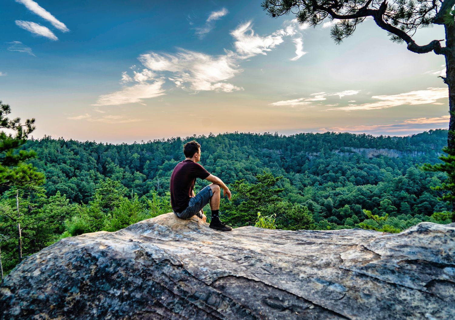
The Red River Gorge is one of the best outdoor rock climbing destinations in the United States.
Climbers from other countries visit this sandstone mecca of spectacular rock formations, such as high cliffs and sandstone arches.
“The Red” also offers hiking opportunities with roughly 500 miles of trails that wind through rocky terrains.
Outdoor enthusiasts visit the gorge all year to enjoy not just climbing and hiking but also camping, canoeing, wildlife viewing, and other recreation activities.

ehrlif / Shutterstock.com
With so many areas, routes, and things to do at The Red, you might feel you’re barely scratching the surface.
The Red River Gorge offers family-friendly accommodations with their lovely cabins and breathtaking treehouses for more extended and more comfortable stays.
The Red River Gorge is federally designated as a National Geological Area, National Archaeological District, and a National Natural Landmark.
It is also on the National Register of Historic Places.

Alexey Stiop / Shutterstock.com

Sean Pavone / Shutterstock.com
Cumberland Falls is heaven for outdoor enthusiasts, with 17 miles of hiking trails winding through the park’s scenic areas.
Located in Cumberland Falls State Resort Park, Cumberland Falls is Kentucky’s largest waterfall.
It stretches 125 feet wide and rises 69 feet tall, dubbed the “Niagara of the South.”
Cumberland Falls is beautiful during the day, but it comes alive at night a few times a month.
The falls’ mist creates an enchanting moonbow (also known as the lunar rainbow), the only moonbow in the western hemisphere.

Jim Vallee / Shutterstock.com
It only appears on a clear night during a full moon.
Unlike many other Kentucky State Parks, Cumberland Falls is accessible 24 hours a day to allow hikers to see the moonbow.
The Moonbow Trail, which connects to many backpacking trails in the Daniel Boone National Forest, is long and arduous so prepare for a challenge.
There are alternative options to see the waterfalls, such as the Cumberland Falls Trail, a half-mile long trail, the most popular route with excellent views of the Cumberland River.

Alexey Stiop / Shutterstock.com
The Cumberland River, which runs through the Daniel Boone National Forest, offers excellent water rafting and canoeing opportunities.
The river is divided into two sections: Upper Cumberland River and Lower Cumberland River.
The Upper Cumberland River runs 17 miles, with most sections rated Class I and II rapids, excellent for advanced beginner skill levels.
The put-in location begins from Redbird Bridge and ends 200 yards above Cumberland Falls, where paddlers must take out immediately to avoid getting carried over the falls.

Alexey Stiop / Shutterstock.com
The Lower Cumberland River, also called “Cumberland River below the Falls” runs 11.6 miles with sections rated as Class III and several challenging rapids.
This is one of the few whitewater sections of the river that runs all year round, but the best runs are during late summer and early fall.
The put-in location begins from the sandy beach of Cumberland Falls State Resort Park and ends in the Mouth of Laurel Boat Ramp.
This section of the Cumberland River can take four to six hours to paddle, best suited for intermediate and advanced paddlers.
Horse camping might be one of the unique experiences you can try in Daniel Boone National Forest.
Horseback riders seeking an outdoor, overnight experience can stay at Barren Fork Horse Camp in Stearns District, one of the forest’s four designated horse camping areas.
Barren Fork Horse Camp is a favorite horse campground with multiple interconnecting riding trails in a forest setting.
A neighboring pond offers fishing opportunities, and a picnic shelter is accessible for group use.
The Barren Fork Horse Camp was initially the location of a coal-mining town under the Barren Fork Mining and Coal Company, which operated from 1881 to 1935.

Karl Swanson / Shutterstock.com
The construction of Wolf Creek Dam on the Cumberland River in 1952 created what would become Lake Cumberland.
Lake Cumberland, dubbed “The Houseboat Capital of the World,” is a haven for water lovers in a landlocked state.
It is the ninth-largest reservoir in the United States and one of Kentucky’s most popular vacation destinations.

Eric Pritchett / Shutterstock.com
The reservoir, which provides flood control and hydroelectric power generation, now has over 50,000 acres of waterways and over 1,000 miles of shoreline.
Lake Cumberland features some of the best fishing spots in the state.
It hosts national competitions where anglers hope to catch various species, including trout, black and white crappie, sturgeon, walleye, and striped bass.

Brian Stansberry, CC BY 4.0, via Wikimedia Commons
The Alpine Picnic Area is in the Stearns District of the Daniel Boone National Forest in Pulaski County.
This picnic area provides picnic shelters, a play area, and the Alpine Loop Trail #520, a short 1.5-mile loop trail.
The chimney stone in the wood picnic shelter is the only remnant of the 1930s farmhouse that once stood on this site.
If you go around the area, you can find traces of old coal mines from the Alpine Coal Camp, which operated from 1884 through the 1930s.
Do not enter the mines, though.

Sean Pavone / Shutterstock.com
The Dog Slaughter Falls, one of the most beautiful waterfalls in the forest, is well worth mentioning.
Dog Slaughter Falls is a 15 by 20-foot high waterfall in the Daniel Boone National Forest’s London Ranger District.

Alisha Bube / Shutterstock.com
You can reach it via the Dog Slaughter Trail or the Sheltowee Trace Trail over massive boulders, which run down towards Cumberland Falls, where the trail ends.
Dog Slaughter Falls Trail runs along Dog Slaughter Creek through dense hemlocks and rhododendrons.
The falls are said to have been named after unwanted pets drowning or dogs being hunted by wild creatures.

Alexey Stiop / Shutterstock.com
The Kentucky Department of Fish and Wildlife Resources and the U.S. Forest Service manage Cane Creek’s vast wildlife management area.
This area hosts a sustainable population of wildlife, both game and nongame species.
The Cane Creek Wildlife Management Area is about 15 miles west of London, Kentucky.
It’s part of the Daniel Boone National Forest, which spans over 6,000 acres of predominantly steep, mountainous terrain with vertical sandstone cliffs beneath the ridge tops.
The land is wooded with scattered meadows and has no developed facilities outside roads and trails.
You can hunt wild turkey, whitetail deer, squirrel, and other small game animals at Cane Creek Wildlife Management Area, following statewide hunting regulations.

ScottymanPhoto / Shutterstock.com
Cave Run Lake is an 8,270-acre lake set in the rolling hills of northeastern Kentucky, located in the Daniel Boone National Forest’s northernmost section.
The U.S. Army Corps of Engineers built the lake for flood protection.
It also provides a habitat for numerous species of wildlife and fish and clean water to the surrounding communities.

Alexey Stiop / Shutterstock.com
Visitors enjoy the lake for its scenery and find many excellent opportunities for relaxation and fun, including camping, hiking, biking, horseback riding, boating, fishing, and hunting.
Cave Run Lake has a network of picturesque trails built for non-motorized use weaving through the forest, offering glimpses of wildlife and striking scenery.
Hikers can access all trails, while separate paths are assigned for mountain bikes and horses.
These trails provide access to popular destinations in the area, such as picnic areas and camping grounds.

Jim Vallee / Shutterstock.com
The ridges, slopes, and cliffs of Daniel Boone National Forest create a breathtaking backdrop of over 100 natural arches in the area.
The Natural Arch Scenic Area, located in the Stearns District of the national forest, is among them.
Its main attraction is a picturesque sandstone arch that spans 50 by 90 feet, with an overlook area offering visitors a panoramic view of the arch.

Richard345 / Shutterstock.com
The arch and its surrounding 945 acres, previously home to Native Americans, including the Cherokee, were kept to preserve its natural beauty.
There are three known hiking trails within the Natural Arch Scenic Area for day use only.
The Natural Arch Trail #510 (1 mile), the Buffalo Canyon Trail #508 (5.13 miles), and the Panoramic View Trail #528 (0.5 miles offer distinct charms.
Picnic areas, shelters, playgrounds, and an amphitheater are also available all-year-round.

Gabriel Quiles / Shutterstock.com
With more than 600 miles of road, the Daniel Boone National Forest is the perfect location for a scenic drive.
Drivers can explore and enjoy the heart of eastern and southern Kentucky’s beautiful forests.
The winding Red River Gorge National Scenic Byway is a popular route offering spectacular views of the forest, approximately 46 miles long with a travel time of roughly an hour.
Some attractions along the byway include the Nada Tunnel, Gladie Visitor Center, stone arches and unusual rock formations, with portions parallel to the Red River.
Zilpo National Forest Scenic Byway is another option if you prefer a shorter route, an 11-mile road with gentle curves and a travel time of approximately 20 minutes per way.
The route winds through hardwood forests, providing views of Cave Run Lake and the opportunity to see wildlife.
Take the time to visit some of the exciting sights along the road.

Alexey Stiop / Shutterstock.com
The Sheltowee Trace National Recreation Trail is the forest system’s “backbone” trail.
Verne Orndorff, a Forest Service employee, created Sheltowee Trace to allow hikers to explore the entire length of the Daniel Boone National Forest.
The Daniel Boone National Forest established the trail as a National Recreation Trail in 1979.

Alexey Stiop / Shutterstock.com
Many more trails connect to the Sheltowee Trace, creating loops for day hikes or long-distance treks.
The trail stretches for 333 miles from the northern borders of the Daniel Boone National Forest in Rowan County, Kentucky, to the south boundaries of Big South Fork National River and Recreation Area in Scott County, Tennessee.
A few of the magnificent spots along the trail are the Cumberland Falls State Park, Cave Run Lake, Laurel Lake, Natural Bridge State Park and Red River Gorge.

Danielsen_Photography / Shutterstock.com
The Beaver Creek Wildlife Management Area is home to various wildlife species and offers hunting and nature viewing opportunities.
The Kentucky Department of Fish and Wildlife Resources and the U.S. Forest Service manage the 17,753-acre property via an agreement.
The wildlife management area encompasses the Beaver Creek Wilderness in the national forest’s Stearns District, where terrains are hilly and steep.
Mixed hardwoods dominate the habitat, with around 150 acres of open fields (92% forest land, 7% available land, and 1% open water) and no facilities.
The Beaver Creek Wildlife Management Area is open year-round.

Patrick Jennings / Shutterstock.com
Laurel River Lake is a 5,600-acre lake known for being one of the cleanest and deepest lakes in Kentucky, located inside the Daniel Boone National Forest.
Thousands of visitors go there for relaxation and exciting water activities every year, including boating, skiing, fishing, and scuba diving.
They also do recreational activities such as camping, hiking, outdoor learning, picnicking, and nature viewing.
Seven launch ramps are conveniently positioned throughout the quiet bays and cliff-lined shores of the lake.
You can also fish for black bass, bluegill, catfish, crappie, rainbow trout, and walleye.
The lake provides excellent locations for wildlife viewing, including Canadian geese, bald eagles, and deers who visit the shoreline frequently.
The pristine waters and submerged rock formations make Laurel River Lake a popular attraction for scuba diving.
The U.S. Forest Service manages the lake and adjacent shoreline, while the U.S. Army Corps of Engineers operates the lake’s dam and nearby recreational facilities.

Patrick Jennings / Shutterstock.com
The Koomer Ridge Campground, located in the Red River Gorge in Cumberland District, is a popular campground within the Daniel Boone National Forest area.
Koomer Ridge Campground provides access to several hiking and trekking paths in the Red River Gorge and near Natural Bridge, featuring semi-primitive camping in a serene forest setting.
The park is open year-round and features 54 tent camping sites and 15 RV camping trailer sites, and picnic tables found at campsites and trailheads.
The amphitheater is open from Memorial Day weekend through Labor Day weekend and hosts interpretative presentations on Saturdays.
Camping in Koomer Ridge Campground admits campers on a first-come, first-serve basis.
Campers can stay for 14 days maximum without special authorization.
Your time spent in the Daniel Boone National Forest will be timeless and unforgettable no matter what season.
Home to many unique species of animals and plants, the vastness of the forest with many multi-use state parks in between makes the Daniel Boone National Forest more diverse than ever.
The Daniel Boone National Forest is a true gem and a magical place worth in-depth exploration.